ES · EN

Manage urban forestry with data, traceability, and technical expertise

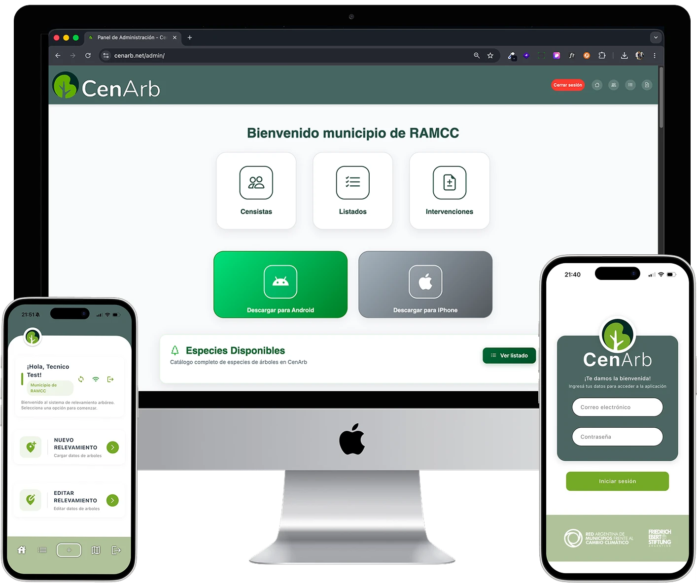
CenArb integrates field surveying, georeferenced inventory, and operational management in a platform built for municipal teams and public institutions.

--
Surveyed Trees
--
Active Municipalities
--t
CO₂ absorbed/year

Connecting API...

Application developed by RAMCC

CenArb combines applied technology with institutional backing to accelerate evidence-based public management.

High-Impact Institutional Proposal

CenArb: Application developed by the Argentine Network of Municipalities Facing Climate Change

We transform scattered surveys and manual spreadsheets into a single source of truth — enabling better decisions, prioritized interventions, and sustainable urban forestry policies.

  • Guided Implementation

    Phased onboarding, role-based training, and technical support from day one.
  • Governance & Traceability

    Full census and intervention history for audits, management, and public accountability.
  • Data-Driven Decisions

    Dashboards, filters, and reports to prioritize by risk, criticality, and territorial impact.
Dashboard view for municipal urban forestry management
+100% Operational Traceability
B2G
Technical, political, and operational teams on a single platform
Mapa de árbolado urbano

1

Integrated Ecosystem

3

Value Pillars: Compliance, Efficiency, Evidence

24/7

Information Availability for Decision-Making

RAMCC

Institutional Backing to Scale Implementations

CenArb Solution

From street-level data collection to municipal planning — all in one platform.

01

Mobile Survey App

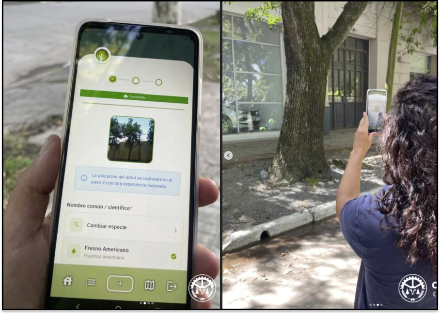
Per-tree data entry with offline mode and automatic sync when connection is restored, geolocation, and photo evidence for field crews and surveyors.

Operational Core
Request demo
02

Georeferenced Inventory

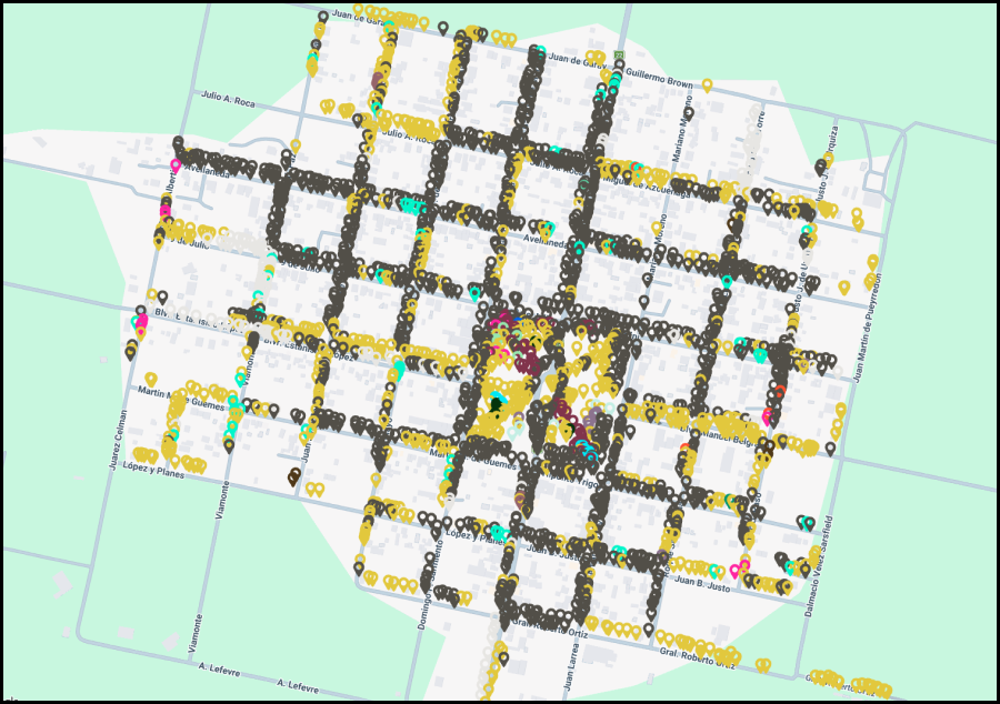
Live urban forestry map with condition, species, dimensions, and intervention history.

Request demo
03

Web Admin Panel

Indicator dashboards, advanced filters, and technical prioritization of interventions.

Request demo
04

Management Workflows

Track pruning, removal, planting, and maintenance with complete traceability.

Request demo
05

Reports & Exports

Ready-made reports for internal management, public accountability, and cross-department work.

Request demo
06

Onboarding & Training

Phased implementation with virtual or in-person role-based training, support materials, and personalized technical accompaniment.

Request demo

Turn your tree census into a public management advantage

We show you a demo tailored to your municipality's context and project stage.

Contract Modalities

Three modalities for municipalities and institutions, all with the same platform features.

RAMCC
RAMCC

For member municipalities of the Argentine Network of Municipalities facing Climate Change.

Up to 50,000 residents On request
Over 50,000 residents On request Differentiated implementation and extended support
2-year license
  • Mobile survey app with offline mode
  • Georeferenced inventory with per-tree record
  • Dashboard, reports and exports
  • Interactive maps and technical filters
  • Onboarding, training and manuals
  • Ongoing technical support
Request proposal
Premium

Platform customization with own branding, sponsors and municipality or institution preferences.

On request Available for RAMCC, Municipal and Institutions
2-year license
  • Mobile survey app with offline mode
  • Georeferenced inventory with per-tree record
  • Dashboard, reports and exports
  • Interactive maps and technical filters
  • Onboarding, training and manuals
  • Ongoing technical support
  • App branding and customization
  • Sponsor and partner institution slots
  • Municipality or institution preferences setup
Request proposal

Benefits for Public Management

Technology, methodology, and institutional backing to turn data into decisions.

Why choose CenArb for your municipality or institution

We integrate compliance, operational efficiency, and technical traceability to reduce risk and improve decision quality in urban forestry.

100%

Intervention Traceability

Per-tree historical record for internal audit, operational continuity, and public accountability.

3x

More Operational Efficiency

Faster surveys, organized data, and reduced operational risk to prioritize interventions with technical judgment.

5

Public Management Benefits

Operational efficiency, better planning, risk reduction, traceability, and institutional communication in one platform.

Implementation Pillars

01
Initial Assessment

We map your operational situation, available data, and policy goals to define a realistic rollout plan.

02
Phased Deployment

Configuration, training, and progressive adoption by role to minimize internal friction.

03
Ongoing Support

We provide technical support and functional improvements aligned with your municipality's management needs.

Regulatory Framework & Best Practices

Jurisdictions across LATAM already require or promote urban tree inventory and traceability.

Regulatory framework for urban forestry management

Compliance with Evidence

CenArb organizes data and processes to respond to audits, internal controls, and public accountability.

Turn a regulatory requirement into management capability

With a single platform you can move from census to planning, prioritizing interventions by risk and territorial impact.

Organized information for government decisions
Per-tree georeferenced traceability
Intervention history and technical follow-up
Indicators for management and local climate policy

Implementation

A concrete methodology to activate fast and sustainable results.

01

Initial Assessment

We define scope, objectives, and data status to plan a realistic rollout.

02

Configuration

We configure the platform, users, permissions, and municipal work structure.

03

Training

Role-based training for surveyors, coordinators, and technical leads.

04

Accompaniment

Operational monitoring and ongoing adjustments to consolidate adoption and results.

Frequently Asked Questions

Answers about how CenArb helps municipalities modernize urban forestry management.

CenArb captures data for every tree: georeferenced location, species, height, diameter, phytosanitary status, interventions, and full history. This generates a dynamic inventory with complete traceability.
The mobile app is designed to work with a data connection, syncing information in real time. For areas without coverage, it includes an offline backup mode that allows surveying to continue uninterrupted; once signal is restored, all data syncs automatically to the web platform for coordinator review and reporting.
Dashboards with metrics by zone, species, and phytosanitary status. Interactive maps to prioritize interventions with technical criteria. Reports for auditing, public accountability, and decision-making. Standard format exports for integration with your existing systems; the detailed Excel export enables data cross-referencing in GIS tools such as QGIS and other municipal management platforms.
Implementation covers environment and user setup, configuration, team training, manual delivery, and support activation — 2 to 4 weeks in total depending on complexity. Field surveying is entirely up to the municipality: teams can begin loading data from day one of activation, at their own pace and census strategy.
Training is delivered externally — not inside the app — through virtual or in-person sessions by role (surveyors, coordinators, and technical leads), support materials, and personalized technical accompaniment.
Operational monitoring in the first weeks, available technical support, adjustments based on team feedback, and follow-up meetings to consolidate adoption and optimize processes.
Yes. Various jurisdictions have frameworks requiring or promoting urban tree inventories. Examples: Santa Fe (Law 13.836), CABA (Law 3263), Quintana Roo, CDMX, and Loja. We consult each jurisdiction to align with local regulations.
CenArb organizes technical evidence, traceability, and intervention history for internal control, audits, and public accountability. It generates reports with metadata and timestamps for regulatory compliance.
You can review our dedicated study at Regulatory Research on Urban Trees (LATAM) with official references and prudent commercial use criteria.
We offer three plans: RAMCC (for member municipalities of the network, with preferential pricing), Municipal (for municipalities and institutions outside the network), and Premium (with platform customization, own branding, and sponsors). All plans include initial setup + annual license. Reach out to discuss the right fit for your operational context.
We are backed by RAMCC, a network of municipalities with expertise in territorial environmental management. We combine SaaS technology + institutional capacity + local knowledge for sustainable results.
Request a demo. We meet to understand your operational context, show the platform in action, and design a proposal tailored to your implementation stage. No commitment — just an honest demonstration.

Note: This content is informational-commercial and does not replace local legal advice for public procurement processes.

Commercial Contact

Let's arrange a demo focused on the operational reality of your municipality or institution.

CenArb: a tool to modernize urban forestry management

If your team needs to organize census, inventory, and interventions, we'll show you a technical and commercial proposal tailored to your implementation stage.

24h Average response time
B2G Public sector focus
RAMCC Institutional backing

Request a demo

Complete these fields to receive a proposal tailored to your municipality or institution.

Sending
Message sent. We'll be in touch shortly.